Beach Restoration in Reverse Chronology
February 25, 2026
Coastal Science & Engineering provided the 2025 Beach Monitoring report.
May 27, 2025
The Wild Dunes Shoal Management Project is complete. Approximately 120,000 cubic yards of sand have been placed in the areas of Ocean Club, Seascape, and Beachwood East. Crews are working to have all equipment cleared from the area by the end of the week.
May 13, 2025
USACE work is progressing, and sand is currently being deposited in the 300 block of Ocean Blvd. Work is expected to continue throughout most of the summer.
City's Supplemental Contractor- This project is complete. Sand from the USACE project has been moved and graded to create a new dune from 9th Avenue to Breach Inlet.
Wild Dune Shoal Management - Approximately 90,000 cubic yards of sand have been placed in the Ocean Club, Seascape, and Beachwood East areas. Crews will return to Beachwood East to place an additional 30,000 cubic yards of sand. This week, the contractor will assess whether more sand is needed in the area around Ocean Club. The project remains on track for completion this week.
May 2, 2025
USACE's work is ongoing north of 3rd Avenue and will continue throughout most of the summer.
The city's supplemental contractor has completed work North of 2nd Ave. The remaining work south of 2nd Ave is expected to be completed by mid-week next week.
- By May 2, 35,000 CY of sand will have been placed.
- By the end of next week, 37,500 CY will have been placed.
Wild Dunes Shoal Management work in the Ocean Club and Seascape area is expected to finish early next week. Crews will then return to the Beachwood East area.
- An initial 40,000 CY of sand was placed at Beachwood East. An additional 40,000 CY will be placed there.
- At least 35,000 CY will be placed in the area around Ocean Club and Seascape.
April 23, 2025
USACE crews are currently working just north of 3rd Avenue and will continue operations throughout most of the summer.
The city's supplemental contractor is now halfway complete. Sand placement has been completed from 6th Avenue through 9th Avenue.
- Sand has also been placed between 4th and 6th Avenues, but grading is still ongoing in that area.
- Work in the vicinity of 5th and 6th Avenues, extending through Breach Inlet, is expected to be completed within the next two weeks.
Wild Dunes Shoal Management crews will shift locations this weekend.
- This weekend, crews will move from the Beachwood East area to place sand in the area in front of Seascape and the Ocean Club Villas. This phase is expected to take around ten days to complete.
- Following that, work will resume in the Beachwood East area and continue until mid-May.
April 11, 2025
USACE has moved to 3rd Avenue. Sand is expected to be placed there on Friday, April 11.
The city's supplemental contractor began work on Monday, April 7 at 10th Avenue and are progressing southward along the beach. They are expected to place sand at a rate of approximately two blocks per week. Work at 7th and 6th Avenues is anticipated to begin the week of April 14.
Wild Dunes Shoal Management crews began work on Wednesday, April 9. Work will continue exclusively in the Beachwood East area for approximately another week. Once that phase is complete, they will shift to the Ocean Club area, where work is expected to continue for a couple of weeks.
April 4, 2025
USACE has paused sand placement in order to extend pipes up to 3rd Avenue and shift operations to a new holding site. Work is expected to resume the week of April 7.
During the week of April 7, the transport of sand by the city's supplemental contractor will begin. The sand deposited will create a new dune stretching from 9th Avenue to Breach Inlet.
Shoal Management: Crews will start mobilizing on Monday, April 7. Sand is expected to be excavated from the approaching shoal and deposited next to Beachwood East, Ocean Club Villas and Seascape Villas. The anticipated completion date is in June.
March 19, 2025
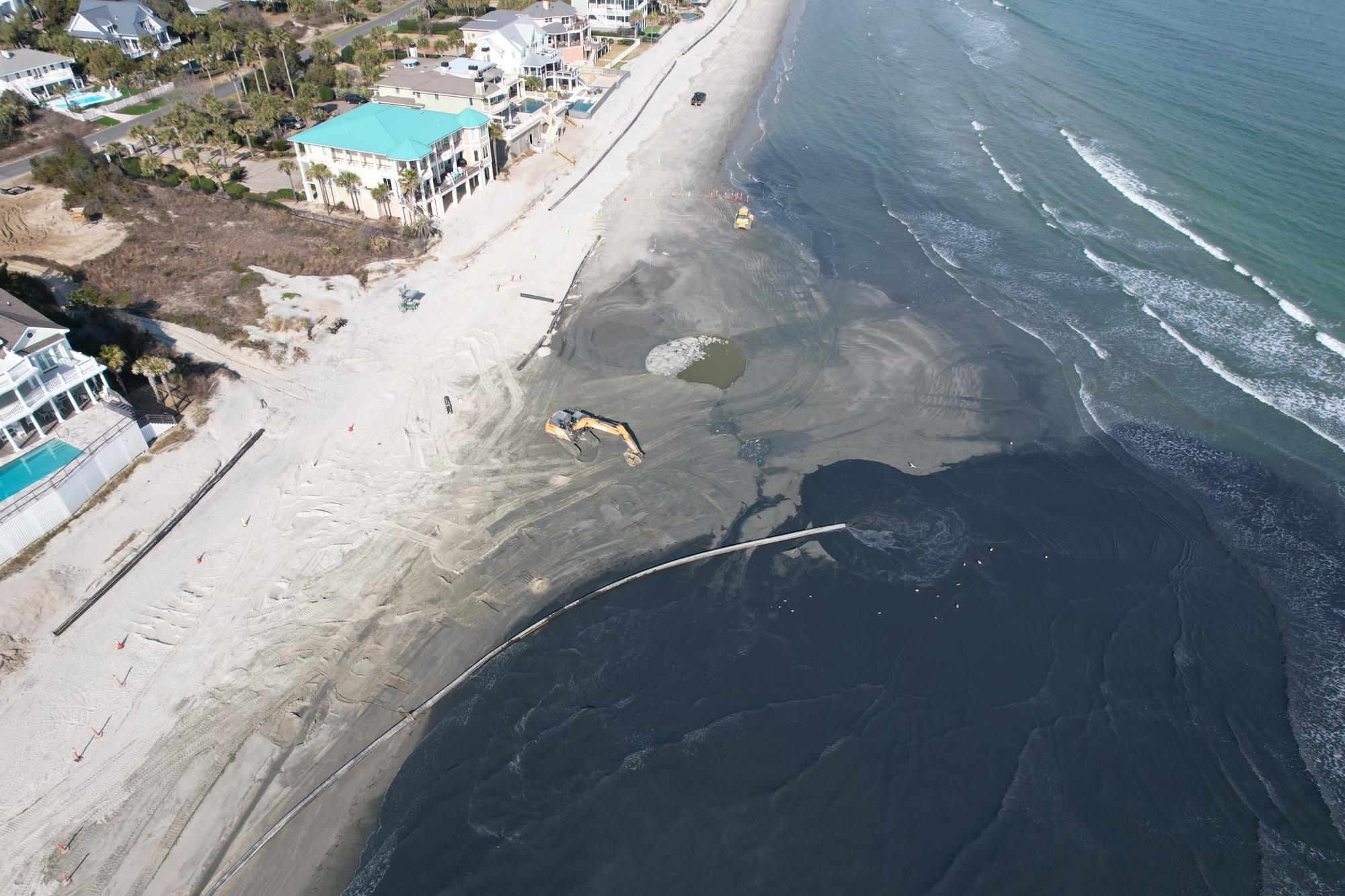
USACE has completed initial work associated with dredging approximately 60,000 cubic yards of material to make the Intracoastal Waterway navigable. Sullivan's Island agreed to allow the contractor to place the remaining 20,000 cubic yards of sand allocated to them onto the Isle of Palms. Now that Sullivan's Island allocation is complete, the contractor has started moving the material allocated to Isle of Palms. The sand will be moved into a protective berm once sufficient material has been placed on the beach.
February 25, 2025
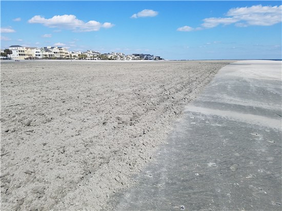
Sand has started to arrive on the Isle of Palms! The photo below shows the area adjacent to 200 Ocean Boulevard.
February 18, 2025
Over the weekend, the USACE dredging contractor, Ahtna, began mobilizing pipes onto the Isle of Palms near Breach Inlet to initiate a beneficial use project that will pump sand from the Intracoastal Waterway onto the beach. The contractor will initially pump sand that has shoaled into the Intracoastal Waterway and then shift their dredging operation back to the upland dredge placement areas. The contractor has indicated that the Intracoastal dredging should last about three weeks, before returning back to the placement area dredging. Ultimately, the project is expected to result in over 500,000 cubic yards of sand onto the Isle of Palms.
February 2025
Coastal Science & Engineering presented the (2024) Monitoring Report for the Isle of Palms beach. Appendix A.
September 27, 2024
Ahtna, the contractor hired by the USACE to perform the beneficial use project, began pumping operations on Sunday, September 22, 2024 at Sullivan's Island. The contractor will continue operations during daytime hours for the first week, and then transition to 24/7 operations. USACE will evaluate the contractor's daily production data to determine production rate and provide the city with a more detailed schedule of when they’ll complete the work at Sullivan's Island and move the sand pumping operations to Isle of Palms.
August 27, 2024
City Council approved an allocation of $200,000 from the Beach Preservation Fee Fund for the installation of additional sandbags along Beachwood East, which is experiencing erosion. The city continues to pursue a permit for the construction of a shoal management project, which involves harvesting sand from an incoming shoal on the north end of the island.
July 23, 2024
At the regular Council Meeting, City Council received an update from Steven Traynum from Coastal Science and Engineering, about the condition of the beach at Breach Inlet and Beachwood East, which continue to be impacted by erosion. City Council approved an emergency expenditure for the installation of sandbags along the erosional area of 130-304 Ocean Boulevard, where properties are within 20’ feet of the erosion, to provide protection until the start of the US Army Corps of Engineer’s Beneficial Use Project this fall. The beneficial use project involves placing approximately 550,000 cubic yards of beach compatible sand along the inter tidal zone between 2nd Avenue and 10th Avenue.
A revised shoal management permit application for the north end project was submitted to the state and federal permitting agencies, removing the sand recycling portion of the project from 44th and 53rd Avenue, from the project application.
July 15, 2024
USACE informed the city that Ahtna, the contractor, decided to shift the order of sand placement based on a review of site conditions. Sand placement will begin at Sullivan's Island in mid to late August.
The work on Sullivan’s Island is expected to take approximately 3-4 weeks. After the sand placement on Sullivan’s Island is complete, the contractor will begin pumping sand on Isle of Palms. It is expected that the work on Isle of Palms will begin in late September 2024 and take 4 months to complete.
June 7, 2024
The USACE has given the contractor approval to begin mobilization to the placement areas to begin initial clearing and dewatering activities. Most of the contractor’s equipment is on site or nearby the AIWW. They anticipate 6-8 weeks of clearing and dewatering activities before they can start delivering sand to the beachfront.
May 22, 2024
City hosts a public meeting regarding the proposed shoal management project on the north end of the island. The public meeting will be held at 5:00 p.m. at the Isle of Palms Recreation Center at 24 28th Avenue.
April 5, 2024
Coastal Science & Engineering submits permit application to OCRM for a shoal management project on the north end of the island.
February 20, 2024
On Tuesday, February 20, 2024, City Council adopted an emergency ordinance allowing owners of beach front properties located between 100 and 914 Ocean Boulevard to install a revetment or seawall entirely landward of the critical area, as determined by the Ocean and Coastal Resource Management office (OCRM).
Coastal Science & Engineering presented the (2023) Monitoring Report for the Isle of Palms beach. Appendix A.
January 23, 2024
USACE Beneficial Use Project
City Council heard a presentation from B. Jacob Kyzer, USACE Project Manager, overseeing the Breach Inlet Beneficial Use Project. The primary purpose of the project is to regain capacity in several upland dredge placement areas along the Intracoastal Waterway by removing beach compatible sand and placing the sand below the high tide line between 10th Avenue and 2nd Avenue. Approximately 550,000 cubic yards of sand will be placed.
Project schedule is not yet complete, but anticipated to begin mid to late May 2024.
At this meeting, City Council formed the Beach Preservation Ad Hoc Committee. The committee is tasked with the following:
- Review beach restoration policies and practices and provide recommendations,
- Develop recommendations for a more proactive response to beach erosion, and
- Develop recommendations for new, consistent, and sustainable funding mechanisms to fund future needs and projects.
The Ad hoc committee held its first meeting on February 9, 2024, and plans to meet every Friday for the next several months. At their first meeting, Steven Traynum with Coastal Science & Engineering gave a presentation of beach condition and preservation efforts on the island since 2007.
December 5, 2023
Collins Construction starts a targeted sand scraping operation between 13 and 17 Beachwood East. Contractor will be accessing the beach via the 53rd beach access path.
November 30, 2023
OCRM issued an emergency order to install sandbags and scrape sand from the beach from 13 to 17 Beachwood East on Isle of Palms due to impacts from recent king tide events.
November 28, 2023
City Council approved $300,000 for emergency erosion control efforts in the area of Beachwood East. The City requested an emergency order from OCRM for sand scraping and placement of sandbags between 12-17 Beachwood East. These properties meet the state’s emergency threshold of being within 20’ of the erosion.
November 13, 2023
The City held a public meeting at the Isle of Palms Exchange Club regarding the upcoming beneficial use project of the US Army Corps of Engineers (USACE) between Breach Inlet and 10th Avenue. The purpose of the meeting was to provide the public with a comprehensive understanding of the project's scope, timeline, benefits, and potential impact. The meeting included a presentation from the USACE about the scope of the project, followed by a presentation from Coastal Science & Engineering, the City's coastal engineer, about the scope of the upland work. City Attorney and City staff discussed the need to secure temporary easement agreements from the front beach property owners within the project limits. A video of the meeting is available here.
October 11, 2023
Sand Scraping
Collins Construction, the City’s contractor, is expected to complete the dune restoration in the next few days. Contractor is restoring the dune between 100 and 314 Ocean Boulevard.
Sandbags
OCRM has authorized the placement of sandbags between 120 and 206 Ocean Boulevard as these properties meet emergency conditions. The city has engaged Collins Construction for the placement of sandbags along this section of Ocean Boulevard. This effort aims to quickly mitigate the impacts of erosion and safeguard property from additional damage. The plan is to restore and stabilize the berm prior to the placement of sandbags. Once sandbags are installed, per the state’s permit, the city cannot continue to scrape sand in front of the berm. The sandbag placement will likely commence early next week and is expected to be completed in several days. Our team will work diligently to minimize any disruption during this period.
Trucking Sand
Collins Construction will begin trucking beach compatible sand from an upland source on Monday. The goal is to add new sand to the system and place additional material in front of the restored dune and supplement the ongoing scraping operation.
Emergency Ordinance 2023-01
At a special meeting held on Tuesday, October 10, 2023, City Council adopted an emergency ordinance that allows front beach property owners between 100 and 914 Ocean Boulevard to install sandbags landward of OCRM's jurisdiction in accordance with certain conditions specified in the ordinance. If you are interested in performing this work in your property, please contact City staff at City Hall 843-886-6428 for additional guidance.
October 4, 2023
City Council held a special meeting on Tuesday, October 3, 2023, to take action to address the beach erosion issue that we have been facing in the south end of the beach, near Breach Inlet. The City's top priority is to ensure the safety and preservation of the beach and front beach homes.
Sandbags
Council approved a budget of $250,000 specifically dedicated to the installation of sandbags. These sandbags will be placed in properties that are in emergency conditions and meet the state's threshold for approval, meaning a habitable structure or pool is within 20 feet of the erosion area. This measure aims to provide immediate support and protection to those properties most at risk.
Sand Scraping and Trucking Sand Operation
Additionally, the Council has allocated $1.250 million to continue sand scraping efforts, supplemented by trucking in beach-compatible sand. The goal is to place up to 50,000 cubic yards of sand in the affected area. By replenishing the beach with this additional sand, we hope to mitigate further erosion and stabilize the area until the completion of the beneficial use project the City is partnering with the US Army Corps of Engineers (USACE). The primary purpose of this beneficial use project is for the USACE to regain capacity in several upland dredge disposal areas along the AIWW by rehandling beach compatible sand to Isle of Palms and Sullivan’s Island. The project involves placing approximately 550,000 – 750,000 cubic yards of sand; approximately 200,000 CY will be placed in Sullivans Island and the rest will be placed at IOP between 2nd Avenue and 10th Avenue. The City’s plan is to engage the same contractor to scrape the sand up from the surf zone into the dry sand beach and enhance the existing primary dune. This work would be done after the sand placed has been adequately cleaned by the tides. The project design is 95% complete. USACE anticipates going out for bid in October, award a contract in December, and start construction in January 2024. Our next step is to host a public meeting for the USACE to give an overview of their project, our costal engineers CSE to explain the scope of the additional beach restoration work to be done by the City and staff explain the need to obtain temporary easements from the front beach property owners through 10th Avenue. We are working on the date and logistics for the meeting and will share those details with you once finalized.
Emergency Ordinance to Allow Temporary Placement of Sandbags
Council instructed staff to draft an emergency ordinance to allow property owners to install of 1 cubic yard sandbags landward of the jurisdiction of the Office of Coastal Resource Management (OCRM). Council is expected to take action on this emergency ordinance at a special meeting next Tuesday, October 10, 2023.
The City understands the concerns and challenges that beach erosion poses to property owners. The City is committed to taking all necessary measures to address this issue promptly and effectively.
September 29, 2023
Portions of the beach in the Breach Inlet area have experienced significant erosion, due to recent king tides. City mobilized crews to restore the dunes in need of emergency repair. Work involved sand scraping to restore the dune in areas where properties met emergency conditions.
September 26, 2023
City Council approved a contract with Coastal Science and Engineering for the following projects:
Scope A: Permitting a sand recycling “shoal management” project in north end Dunes [$69,534]
Scope B: Initial sand search, geophysical data collection, and State Historic Preservation Office (SHPO) coordination to begin the process of identifying borrow areas for future nourishments at the north and south end [$168,895]
Scope C: Coordination with the US Army Corps of Engineers (USACE) on the beneficial use project proposed for the southern end of the island, as well as construction planning and administration for dune enhancement project in connection with the USACE project [$85,069]
September 14, 2023
The emergency berm restoration project between 100 and 314 Ocean Boulevard and 11-20 Beachwood East was completed.
September 1, 2023
Some areas of the Isle of Palms coastline experienced significant erosion due to Hurricane Idalia. The city took immediate action to restore its beaches and ensure their long-term sustainability. The city launched a comprehensive beach cleanup and restoration effort that will continue over the next few weeks. The City obtained an emergency order from OCRM that allowed sand scraping to restore the dune between 100 and 314 Ocean Boulevard and 11-20 Beachwood East.
January 2023
Coastal Science & Engineering presented the Year 4 (2022) Monitoring Report for the Isle of Palms beach. Appendix A.
Coastal Science & Engineering presented the Year 3 (2021) Monitoring Report for the Isle of Palms beach.
May 17, 2020
Coastal Science & Engineering presented the Year 2 (2020) Monitoring Report for the Isle of Palms beach. The beach nourishment project area was fairly erosional, however, high erosion rates in the center of the project area where not seen as they did the previous year. The remainder of the island mostly gained sand, and in areas that showed some minor volume loss, the dune and dry sand beach remained healthy, with the loss occurring underwater.
August 8, 2020
Coastal Science & Engineering presented the Year 1 (2019) Monitoring Report for the Isle of Palms Beach.
February 11, 2020
The City's permit modification request went out on public notice. The public notice ends on February 27, 2020.
January 23, 2020
The City requested a modification to the 2018 nourishment permit to allow for dune restoration along a small section of Breach Inlet. The modification requests permission to scrape up to 6,000 cubic yards of sand from the accreting shoals of Breach Inlet and to construct a new dune 6 ft high along up to 1,900 liner feet of shoreline.
April 29, 2019
Coastal Science and Engineering submits final report on the 2018 Beach Renourishment Project. Read the final report.
April 25, 2018
Soft Sand in Isle of Palms Restored Beach Following Rain and Tide Event
Walking on the highest points of tilled areas affords the most stability.
The City of Isle of Palms has received reports from citizens of soft sand in the recently restored beach. In response to these concerns, the City has investigated conditions and worked with the City's Coastal Engineering Firm. Coastal Science & Engineering (CSE) assessed the situation this morning and reports that the soft sand is due to a combination of significant rain and tidal over wash of the berm which has saturated the berm and created a "waterlogged" beach.
"This soft sand creates conditions requiring beachgoers to use extreme caution when traversing this area," states Mayor Jimmy Carroll.
"Please be aware that beachgoers might unexpectedly step into one of these pockets of soft sand. Those beachgoers having physical challenges may wish to avoid the area of the beach from approximately access 57 to Dewees Inlet until this phenomenon concludes within the next couple of days and the shore is more stable," continues Mayor Carroll.
What has intensified this event is that the recent weather is the first significant rain event since the restored beach has been tilled. Tilling of the berm, which was required by the permitting agencies, is meant to reduce the sediment compaction so that the sand placed is loose enough to ensure suitable nesting habitat for sea turtles. Tilling loosens the sand and increases the pore space (amount of air) in the sand. When water is added to the freshly tilled sand, it fills the voids and creates the soft sand the beach is experiencing. It is expected that the beach should dry out in 2-3 days of good weather, and return to normal.
"The only remedy for this occurrence is time and repeated rain and over wash events, which will sort the sand to a natural compaction level where less water will be retained in the berm," says CSE Coastal Scientist, Steven Traynum. "We will continue to monitor the situation and the duration of the saturation and recovery of the newly restored beach. Until the beach dries, we recommend beachgoers use caution while walking over the berm."
The City is placing signs around the affected area alerting beachgoers of the soft sand. The area of the beach along the water line is not affected.
April 1, 2018
The sub-line pipe was safely and successfully removed from the Isle of Palms beach.
March 28, 2018
Great Lakes Dredge and Dock has completed tilling all areas of the beach which were recently nourished. The beach nourishment project permits require that the sand placed be loose enough to ensure suitable nesting habitat for sea turtles.
The Dredge Illinois left the project area this morning en route to Norfolk, Virginia. The offshore sub-line pipe that runs from the shore to the dredge will be removed when the weather is suitable and contractor deems it safe.
March 26, 2018
Great Lakes Dredge and Dock completed the sand pumping operation on Friday, March 23, 2018. They will continue to demobilize the pipe and land side equipment from Wild Dunes to the area around 53rd Avenue. This will be temporary while the trucks pick up and remove the equipment. Great Lakes Dredge and Dock is tilling the beach today.
March 21, 2018
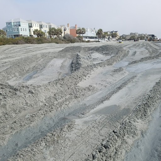
As of today, approximately 1,583,453 cubic yards of sand have been placed on the beach and the project is roughly 97% complete. Remaining work includes placement of remaining sand, tilling and restoration of construction areas. Great Lakes Dredge and Dock has started demobilizing land based equipment.
March 14, 2018
As of March 13, 2018 approximately 1,333,445 cubic yards of sand have been placed on the beach and the project is roughly 80% complete, inclusive of the additional FEMA eligible 276,518 cubic yards of sand.
March 8, 2018
Great Lakes Dredge and Dock, LLC tilled the newly restored beach which should aid in the absorption of storm surge from the recent nor'easter.
March 7, 2018
It is hoped that the dredge resumes pumping operations mid day on Thursday, March 8, 2018. A survey conducted on February 27th shows that approximately 1,124,989 cubic yards of sand has been placed and the project is roughly 78% complete.
The City received final approval from FEMA related to the City's Subgrant Application to replenish 276,518 cubic yards of sand lost on the Isle of Palms beach as a result of Hurricane Irma. The total project cost is $1,731,278.25, of which FEMA will reimburse the City 75%. On January 16, 2018, City Council approved a change order to the existing contract with Great Lakes Dredge and Dock, LLC for dredging the additional sand and to fund the 25% local share. Wild Dunes LLC, contributed $150,000 towards the local share.
March 6, 2018
The dredge has been taken to Charleston Harbor and is undergoing repairs to the anchor wires.
March 5, 2018
Residents may notice that the berm has standing water due to the higher than predicted high tides. The tide is over a foot and half higher than predicted due to the nor'easter creating higher than normal swells. Over wash of the berm is expected to occur occasionally during extreme tides or weather events and is also occurring in other areas of the island outside of the nourishment project area. As the nourished beach adjusts to the natural wave climate and tide conditions, over wash is expected to be less frequent.
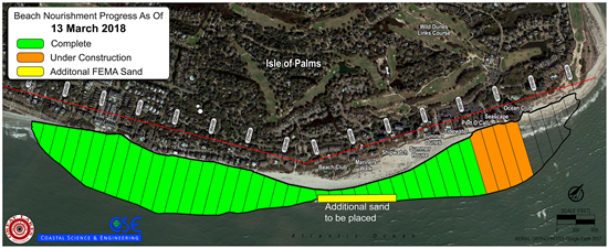
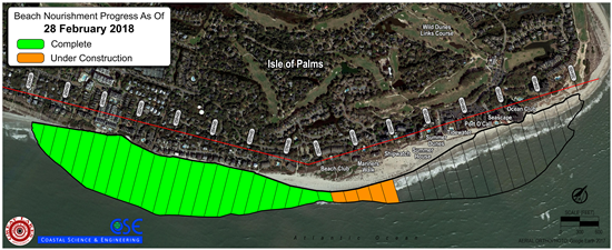
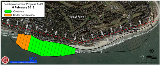
February 28, 2018
Beach Nourishment Project progress map as of February 28, 2018.
February 23, 2018
Citizens should expect restricted access on the beach in the area of the Property Owners Beach House on Saturday, February 24 and Sunday, February 25.
February 22, 2018
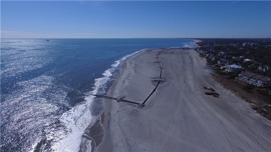
Photos of the Beach Restoration Project progress.
February 21, 2018
As of this morning, approximately 890,325 cubic yards of sand have been placed and the project is roughlt 61% complete.
February 20, 2018
A mud roller can develop from a sand deposit when a layer of soft mud accumulates in a dredge pipe and forms a ball, or can be produced from chunks of stiffer mud (clay) deposits that break off and are smoothed while in the pipe
Mud rollers are not biologically significant, as they were likely buried by several feet of sand in the borrow area. If they are in the surf zone, they will naturally erode and go away. If they are in the dry beach, they will harden.
In addition to mud rollers, other possible unpleasant material that can be encountered in dredge projects are cemented shell deposits (essentially rocks) which may be present among sand.
In the City's current Beach Restoration, Great Lakes Dredge and Dock Corporation (GLDD) has moved away from the area having the highest concentration of clay deposits; but the area is proving to be very patchy, with small pockets of this material interspersed with good material.
Prior to the initiation of the dredging project, extensive sampling of the offshore zone of IOP was conducted to identify the areas having the best material; however, it was known that there was a chance that pockets of lesser quality material were present.
Significant mud rollers were not expected based on the borings, and GLDD has been very cooperative in adjusting to avoid the bad material. There will be some of the clay rollers buried in the fill that will be exposed over time as the beach erodes. The City's contractors are tracking the material several times a day and doing everything possible to put the best material available on the beach.
Attempts to remove as many of these mud rollers as can be removed are underway.
February 16, 2018
The City and Coastal Science and Environmental have been monitoring the presence of mud rollers on the beach. Great Lakes Dredge and Dock, LLC has moved the dredge out of the borrow area which was producing this material and has not encountered any more clay.
February 14, 2018
As of this morning, ~674,205 cubic yards of sand have been placed and the project is approximately 46% complete.
February 10, 2018
The Dredge Illinois has returned to Isle of Palms and resumed pumping operations.
February 7, 2018
Great Lakes Dredge and Dock will move the Dredge Illinois into Charleston Harbor for replacement of a turbo in the pump. Great Lakes Dredge and Dock hopes to be back in position at the IOP Beach Restoration borrow area late Thursday evening, February 8th.
Progress on the project to date is that 660,000 cubic yards of sand have been placed.
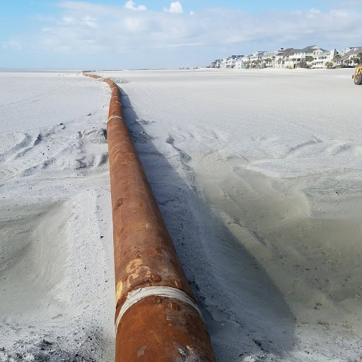
Pedestrians using the beach in the construction area should only cross the dredge pipe using the sand ramps like the ones seen in this photograph.
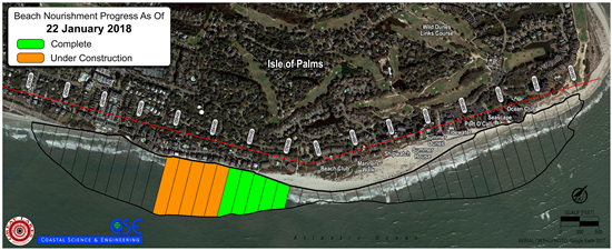
February 6, 2018
Beach Nourishment Project progress map as of February 6, 2018.
January 31, 2018
The Dredge Illinois has returned to Isle of Palms and resumed pumping operations.
January 30, 2018
The Dredge Illinois has been moved to Charleston Harbor for pump repairs and it is expected to return to the Isle of Palms in several days.
The City received the amended US Army Corps of Engineers permit authorizing the increase of maximum nourishment volume in the project area east of 53rd Avenue from 1,400,000 to 1,685,000 cubic yards to compensate for losses occurring in this area during Hurricane Irma. The original permit also includes placement of up to 600,000 cy west of 14th Avenue; however, that scope of work is not part of the present dredging project.
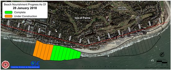
January 28, 2018
Beach Nourishment Project progress map as of January 28, 2018.
January 24, 2018
Great Lakes Dredge and Dock, LLC reports that as of this morning approximately 275,000 cy of sand has been placed on the beach.
January 22, 2018
Work has been completed on the beach west of Property Owner's Beach House in front of Beach Club Villas I and portions of Dunecrest Lane. Under construction at this time is the remaining area of the beach in front Dunecrest Lane and portions of Beachwood East.
January 18, 2018
The City received the amended SCDHEC permit authorizing the increase of maximum nourishment volume in the project area east of 53rd Avenue from 1,400,000 to 1,685,000 cubic yards to compensate for losses occurring in this area during Hurricane Irma. The original permit also includes placement of up to 600,000 cy west of 14th Avenue; however, that scope of work is not part of the present dredging project.
January 16, 2018
Great Lakes Dredge and Dock, LLC begam the sand pumping operations today. Citizens may expect restricted access in work zones. Activity is expected near Dunecrest Lane, Beach Club Villas and possibly Property Owners Beach House.
January 10, 2018
The submerged pipes and the land based equipment are in place and the Dredge Illinois is located at Charleston Harbor. Weather permitting, the expectation is that the dredge will be moved from Charleston Harbor to the offshore location off of the Isle of Palms shoreline and begin pumping sand next week.
December 27, 2017
Great Lakes Dredge and Dock Company, LLC has begun the process of using heavy equipment for offloading pipe at the 53rd Beach Access path and onto the beach. It is anticipated that over approximately the 27th, 28th and 29th most of the land base equipment will be in place.The actual dredge is on its way from Norfolk with a possible stop inNorth Carolina if seas are too rough for transport.Weather and maintenance may affect exactly when the dredge will be on site and working, but the goal remains that the work will start around the first of the year and be completed by approximately the end of March.
December 13, 2017
Great Lakes Dredge and Dock Company, LLC began to mobilize its land based equipment and some of the piping on the island to be prepared to initiate the beach restoration project once the dredge arrives from Norfolk, Virginia. Some of the land based equipment is being delivered now and more will likely continue through the weekend. Great Lake Dredge and Dock will place the subline on the beach this weekend in the vicinity of Beach Club Villas and Dunecrest. There remains no perfect pumping start date to publicize because mobilization has many variables. Once the dredging is underway, work will occur 24/7 unless conditions at sea require a shut down. The majority of the stored land based equipment will be in the vicinity of Property Owners Beach House and on the beach seaward of the homes on Summer Dunes Lane.
December 8, 2017
Following Hurricane Irma, Coastal Science and Environmental completed an emergency beach survey and assessment of the Isle of Palms shoreline to document beach volume changes, escarpment formation, dune erosion and debrisSee the profiles of the Isle of Palms beach before and after Hurricane Irma.
September 20, 2017
The City held the pre-construction meeting with representatives from the City's Coastal Engineer, Coastal Science & Engineering, and Great Lakes Dredge & Dock Company, LLC. The contractor has a window of work between October 1, 2017 and March 30, 2018.
September 12, 2017
As a result of the aftermath of Hurricane Irma, and its impact to the City's beach, the City awarded an emergency contract for protective measures to Robert Collins, LLC to do an emergency berm restoration from Breach Inlet to 10th Avenue, 56th to the area of the beach adjacent to Grand Pavilion and Seagrove, Beachwood East and Ocean Club. This work is expected to take several weeks to complete.
Map of emergency berm work on South end of IOP.
Map of emergency berm work on North end of IOP.
August 22, 2017
City Council awarded a contract of $11,875,000 to Great Lakes Dredge and Dock Company for the Beach Nourishment Project.
August 15, 2017
The City opened bids for the Beach Nourishment Project. Read the Bid Tabulation.
August 1, 2017
The City held a mandatory pre-bid meeting with interested contractors to discuss the work expected for the beach renourishment project, followed by a site visit.
July 25, 2017
Beach Restoration Project Update and Beach Restoration Project Worksheet
July 20, 2017
The Federal Emergency Management Agency obligated funds towards the City's Beach Nourishment Project, related to the damage to the beach as a result of Hurricane Matthew. FEMA has committed to a total project of $3,952,340.11 of which they will fund 75% or $2,964,255.08.
July 18, 2017
In compliance with the City of Isle of Palms procurement code, the City is seeking bids for the Isle of Palms Beach Nourishment Project. A mandatory pre-bid meeting will be held at 9:00 a.m., Tuesday, August 1, 2017 at the Wild Dunes Property Owners Beach House, 6600 Palmetto Drive, Isle of Palms. The deadline for submission is 9:00 a.m., Tuesday, August 15, 2017.
June 30, 2017
The City of Isle of Palms received a grant award of approximately $3.4 million from the South Carolina Department of Parks, Recreation and Tourism. This award brings the total of available funds to approximately $11.5 million. While additional funding participation is pending, relative to restoration of the beach following Hurricane Matthew, the City anticipates being fully prepared to award a contract by having completed all specifications and contract conditions upon receiving the final funding piece.
The City hopes that a competitive bid climate may enable execution of the project as near as possible to the way it was originally contemplated. Assuming expected milestones are achieved, the goal is to bid the project with the expectation of proceeding with nourishment in a window between October 1st, 2017 and March 31, 2018.
June 8, 2017
The SCDHEC Office of Ocean and Coastal Resource Management has reviewed the City's application for the beach restoration project and issued a permitauthorizing the project.
April 17, 2017
The City received the U.S. Fish and Wildlife Service's (Service) Biological Opinion (BO) based on their review of the proposed beach restoration project, which includes their recommendation that no work be performed between July 1 and September 30.
March 13, 2017
On behalf of the City of Isle of Palms, Coastal Science and Engineering submitted the cultural resource report, prepared by Tidewater Atlantic Research, Inc for the Isle of Palms Beach Restoration Project. The surveys encompass the three proposed borrow areas identified in the joint permit application.
March 10, 2017
On behalf of the City of Isle of Palms, Coastal Science and Engineering submitted a response to the comments issued by the permitting agencies, South Carolina Department of Health and Environmental Control, Office of Ocean and Coastal Resource Management and US Army Corps of Engineers.
February 24, 2017
Per FEMA's request, Coastal Science and Engineering adjusted the volume change calculations used in determining the sand losses associated with Hurricane Joaquin and Hurricane Matthew. Revised Damage Assessment.
February 14, 2017
The City submitted the SC PRT Application for Beach Restoration funding.
February 1, 2017
Private funding: As of February 1, 2017, an important project milestone was achieved and the City is in receipt of 100% of the approximately $5,000,000 private stakeholders funding for the next large scale Beach Restoration Project. Documentation of these funds deposited to the Beach Restoration Account, together with the City's budgeted commitment of approximately $2.8 million dollars, will be used to prove the local share of funding in the grant application to be submitted to South Carolina Parks and Recreation Tourism.
Stakeholder Agreements: A few of the executed and witnessed stakeholder agreements remain outstanding, but those remaining outstanding have been contacted and the agreements are expected back to the City.
Permitting: The comment period, for the combined South Carolina Department of Health and Environmental Control, Office of Ocean and Coastal Resource Management and US Army Corps of Engineers joint permit application, is closing February 9, 2017. Coastal Science and Engineering is in the process of receiving and responding to comments/requirements on the permit application from the environmental agencies. As of this update, all agencies have not completed their comments.
Engineering: The City must take steps to engage services and initiate the remaining engineering on the project to shepherd the project through final design, bidding, contract award and construction oversight.
SC PRT Grant Application: The application must be completed, which will require adjusting the schedule originally contemplated. The original schedule planned to accomplish the project in the winter of 2017.
Historic Site: As part of this Beach Restoration, the City learned of the discovery of the possible resting place for the Second Stone Fleet located just offshore from the Isle of Palms, and the designation of this area as a proposed historic district. Some of the best quality sand for restoration of the Isle of Palms beach is found in a proposed borrow site lying within the proposed Historic District. This area was adjacent to the same borrow area used in the 2008 Beach Restoration. While it remains the intent of the City to work on a compromise with South Carolina Historic Preservation Office to be able to harvest sand from this area in the future, in order to remove the delays that would be caused by tasks associated with developing that compromise, the City will utilize sand from outside the proposed district.
Federal Disaster Declarations Hurricanes Joaquin and Matthew: The City, South Carolina Emergency Management Division and the Federal Emergency Management Agency continue to work together to agree to elements of a Project Worksheet which may establish FEMA's participation in the recovery expense associated with sand losses during these storms.
Timing: Many have asked about the timing of the actual work. Too many factors, over which the City has little control, impact the answer to the question of timing. Therefore, at this time, the City is not able to provide a satisfactory prediction. Those unknown factors include obtaining the permits and evaluation of any stipulations placed on the permits, receipt of funding awards, amount of funding awards, stipulations regarding timing which could be imposed by funding agencies, the amount and number of bids, which is affected by the availability of dredging equipment in the area.
Imminent Tasks: Imminent tasks are as follows:
- Obtaining 100% of the fully executed Stakeholder Agreements,
- Completion and submission of the SC PRT grant application,
- Contracting for remaining engineering services,
- Securing the joint permit.
December 21, 2016
Comments regarding the beach renourishment project application must be received by the South Carolina Department of Health and Environmental Control on or before January 21, 2017 - Joint Permit Application Public Notice.
Comments may be sent to Matt Slager via email or mailed to:
SC DHEC-OCRM, Attn: Matt Slagel 1362 McMillan Avenue, Suite 400 Charleston, SC 29405
November 29, 2016
The City submitted an amended permit application including the area of Breach Inlet and 14th Avenue for beach renourishment activities.
November 2, 2016
The City submitted a permit application to permitting and regulatory agencies for the next beach restoration project.
November 2, 2016
Coastal Science and Engineering provided to the City a report with the results of Hurricane Matthew's post storm survey and recommendations.
October 13, 2016
The City approved an amendment to the contract with Ashridge/Lake Moultrie, Inc. to extend the scope of the emergency berm repair work to 202 Ocean Boulevard through 522 Ocean Boulevard.
October 10, 2016
The City awarded two contracts for emergency work as the result of Hurricane Matthew. The City executed a contract with Ashridge/Lake Moultrie, Inc., under OCRM's Emergency Order, to perform emergency berm repair by pushing sand back up in the areas of Beachwood East/4,5 & 6 Dunecrest Lane, Grand Pavilion, Seascape and Ocean Club Building 1 where dune damage is critical and structures are significantly threatened. The City also awarded an emergency contract to Coastal Science and Engineering to perform a post-storm survey of the beach and to supervise the berm restoration project. The City has made a request to the National Guard for assistance in restoring the dune system throughout the full length of the island.
August 29, 2016
Mayor Cronin met with representatives of the State Historic Preservation Office, FEMA, SC Emergency Management Division, and the the State's Underwater Archaeologist to discuss the proposed historic district and a path forward that would allow the preservation of the area while allowing the City to harvest beach compatible sand for the beach renourishment project.
August 23, 2016
City Council adopted a resolution authorizing the submittal of an application to the South Carolina Department of Parks, Recreation and Tourism for beach restoration funds.
City Council approved a contract amendment to Coastal Science and Engineering in the amount of $125,750 for a change in the scope of work involved with locating a new borrow site for the beach renourishment project.
July 28, 2016
City Council received the Year 7 Monitoring Report following the 2008 beach restoration project.
July 12, 2016
The City continues to work on the permitting of a large scale beach renourishment project for the winter of 2017. The City learned that the State Historic Preservation Office (SHPO) is working to delineate an area offshore IOP as proposed for the National Register of Historic Places. This would create a historic district for that area due to the possibility of its containing shipwrecks and the submerged landscape of the Second Stone Fleet. The Second Stone Fleet was a group of thirteen (13) old whaling vessels secured by the Union forces and filled with rocks that were sailed into Charleston Harbor and sunk as part of their blockade of the port.
The City's proposed offshore borrow areas are within the proposed new historic district. The City is now taking some additional samples in other locations outside the proposed National Register of Historic Places boundary to see if it is possible to locate compatible material close to the shore, but outside of this boundary.
April 7, 2016
The City's current shoal management permit has been amended to authorize increasing the total project volume of sand that is scraped from an accreting area of beach or an attaching shoal and transferred to an eroding of beach. Read the amended permit from DHEC.
March 2, 2016
City staff met with FEMA representatives to finalize the Project Worksheet related to the damages to the beach as a result of the October 2015 storm.
December 30, 2015
Mayor Cronin and City staff discuss the need for dune protection and dry sand preservation during a post-storm visit by FEMA officials.
October 30, 2015
Coastal Science and Engineering provide to the City the Post-Storm Survey Results.
October 6, 2015
As a result of the historic flooding event, City Council approved a motion to award a contract to Coastal Science and Engineering for emergency, post-storm erosion assessment. Read the minutes of the Special City Council meeting.
August 31, 2015
The City's Fiscal Year 2016 budget (covering July 1, 2015 to June 30, 2016) includes some funding for a Shoal Management project; however, the exact dates of project construction are yet to be determined. Several steps must take place before a construction schedule can be finalized. First, the City has submitted a request to the state and federal regulatory agencies to amend the existing permit to allow the movement of additional quantities of sand and to allow additional construction events within the permit window. Second, all of the funding must be assembled for the project. The City's FY16 budget contemplates the City contributing a portion of the estimated $1,300,000 in project expense, so the gap in funding will need to be contributed by other stakeholders.
Multiple factors are involved in the selection of the construction window: proximity of the shoal to the shore, volume of accessible sand on the shoal, requirements of existing state and federal permits, potential impact on turtle nesting and hatching seasons, potential impact on the beach season, availability of a qualified construction vendor, and timing of equipment mobilization. Presently, entities other than the City have installed erosion control measures such as sandbags and wave-dissipation devices which are not City projects and not under City control. These projects are operating under permits issued by regulatory agencies to parties other than the City. State regulators have informed the City that they would require removal of any emergency erosion measures, including sandbags and wave-dissipation devices, before a project can go forward.
The type of shoal management project being planned for is similar in scope and nature to the project executed last fall and winter. It is smaller than the project in 2008 that involved an ocean dredge piping sand onto the beach from offshore. This project would involve three to six large trucks driving on the beach and up to two excavators.
This reverse chronology is updated whenever accurate information is available and is the best place to verify information. For now, residents and visitors should be mindful that the City is working toward a project that could take place between October 2015 and March 2016, but nothing is finalized. The City is aware that scheduling visitors and guests is important and so is ensuring that people have an accurate understanding of what to expect during their time on the island. Information will be distributed as soon as it is known. Thank you for your patience.
June 23, 2015
City Council approved award of a contract to Coastal Science and Engineering in the amount of $177,304 for beach condition monitoring for the entire Isle of Palms beach for the years 2015, 2016, and 2017.
May 26, 2015
City Council approved a motion to authorize Coastal Science and Engineering to seek approval from the state and federal agencies to augment the City's permit to allow for an additional volume of sand and for a more flexible time period to get started on the next project as early as September 2015.
April 17, 2015
City Council received the Year 6 Monitoring Report.(5.46 MB)
March 16, 2015
Sand hauling for the shoal management project ended on February 19, 2015. The project transferred 240,00 cubic yards of sand fro accretional areas from 53rd through 56th Avenues and near Mariners Walk and Shipwatch. Approximately 70,000 cubic yards were placed along the Beachwood East/Dunecrest area, and 170,000 cubic yards were placed near Seascape, Ocean Club and the 18th hole of the Links golf course. The total cost of construction was approximately $926,000, which is equivalent to a net cost of $3.87 per cubic yard hauled. This compares to average costs of offshore nourishment sand ranging between $8 to $10 per cubic yard. Even with the addition of sand with the project, configuration of the approaching shoal is continuing to cause erosion, especially during high wave and tide events. It is likely that some areas of the project will need additional mitigative measures prior to the next permit window for another shoal project which is November 2015 - April 2016. Click here to view aerial pictures of the project area and the entire 7-mile Isle of Palms beach taken today.
February 20, 2015
Sand hauling for the project has been completed. Baker will continue to grade the fill this weekend with the bulldozer and will be removing equipment and materials through next week.
February 18, 2015
Based on the condition today, Coastal Science and Engineering instructed Baker to split the remaining fill between both fill areas. Two trucks will be hauling to the western fill area and one to the eastern fill area. Filling will continue through Friday afternoon. Baker is presently shaping the fill with the bulldozer to the design elevation. This may continue after Friday, but no additional sand will be hauled after Friday.
February 9, 2015
Baker is currently working every day, all day during daylight hours to harvest sand from the intertidal beach between Shipwatch and the Property Owners Beach House. Sand is primarily being placed in the eastern fill area. Work is expected to continue through late February, but the schedule is subject to change.
February 2, 2015
Construction has resumed, and work this week will continue off the shoal. Currently, Baker does not plan to work on Sunday, February 8th or Monday, February 9th. Work on Saturday, February 7th will depend on conditions. The City appreciates the continued patience of residents and visitors. Please keep a safe distance from the project and the equipment.
January 28, 2015
View a ground-level and aerial photo gallery of the project.
January 23, 2015
As work progresses, the shoal is becoming lower, meaning less sand is visible during normal and neap (higher low) tides. There is still sand available during spring tides. Baker has been consistently productive for the past two weeks. The design quantity has been placed along the Beachwood East/Duncrest area, and remaining sand will be placed solely in the eastern fill area. Areas needing regrading to the design template will be determined towards the end of the project. Construction will not occur from Sunday, January 25 through Wednesday, January 28.
January 13, 2015
Baker continues working to harvest sand from the shoal and place it at both fill locations. Work will continue in this fashion this week and over the weekend. The next scheduled break is Janury 24th-26th.
January 5, 2015
R.B. Baker continues to move sand from the shoal during low tides, presently placing sand in the eastern fill are near Ocean Club and the golf course. Once a new bulldozer arrives on site, the sand piles in each fill area will be leveled out to produce a smooth berm. Sand hauling will continue over the next month in a similar fashion. R.B. Baker will place additional sand along the area near Beachwood East and Dunecrest Lane beginning later this week or once the new bulldozer arrives.
January 2, 2015
R.B. Baker resumes work today by harvesting sand from the shoal via the constructed causeway connection. Sand is expected to be placed in the area of Ocean Club for the next several days. A top priority is to locate a replacement bulldozer for the non-operational one. Once a replacement is located, the piles of sand on the beach will be leveled. Each day, construction will take place during the two-and-a-half hours on either side of low tide. No work can occur at high tide. When trucks are operating on the wet sand portion of the beach, visitors should please avoid that area.
December 23, 2014
Baker has stopped working for the day and will break for the holiday week. Work will resume on January 2, 2015. Due to an equipment breakdown, the bulldozer has been non-operational ad has not been able to smooth the piles, so they will have to be there during the break. Baker plans to bring in a new bulldozer once work resumes. The dozer can not be moved at the moment, so it will remain near the high-tide line near the Property Owners Beach House. The wheeled vehicles will be stored at the Citadel Beach House and the remainder of the equipment will be stored off of the beach during the break.
December 19, 2014
R.B. Baker continues to work exclusively off of the shoal. They are placing sand in both fill areas. They will level the piles before leaving for the holiday break from December 24, 2014 to January 1, 2015.
December 16, 2014
Over the past weekend (December 13-14), R.B. Baker established a causeway connecting the beach to the shoal which was offshore of Wild Dunes. Work in the near term will continue by harvesting sand from the shoal around low tide (typically 2-3 hours before and after low tide) and placing the sand in the fill areas. Work will concentrate on the area between the Wild Dunes Property Owners Beach House and the Links golf course this week and into the weekend. Beginning sometime near Sunday, December 18, sand will be placed along the narrower areas of the western fill site near Beachwood East and Dunecrest Lane. No additional harvesting is anticipated in the area between 53rd and 56th Avenue. The beach will be available for public used when the contractor is not working close to high tide. No work will be done between Christmas Eve ad New Years Day.
December 13, 2014
R.B. Baker began working today on building an access pathway connecting the intertidal beach to the shoal which is just offshore. Once the pathway is complete, likely in two to three days, R.B.Baker will begin harvesting sand from the shoal during low tides, when the shoal is above the water. The current work plan is for R.B. Baker to work the area between Beach Club Villas and the Links course through the holiday break. No work is planned to occur between Christmas Day and New Year's Day. As the project progresses, adjustments may be made to the work plan to best utilize the working times and available sand sources. Updates will be posted as soon as they become available.
December 1, 2014
R.B. Baker is working on the East end today and tomorrow and plans to return to working on the West end on Wednesday. Sandbags are still being removed from Beachwood East, which should continue through Thursday. No work is expected over this weekend.
November 25, 2014
As of yesterday evening, the contractor, R.B. Baker, has moved approximately 79,701 cubic yards of sand. Nearly 2,000 loads (approximately 56,600 cubic yards) have been placed along the eastern fill area (Seascape, Ocean Club, and the 18th Hole). Eight Hundred loads (approximately 23,000 cubic yards) have been placed along the western fill area (Beachwood). The recent tides and waves produced significant profile adjustment, where much of the sand placed along the upper beach shifted to lower in the beach profile, resulting in loss of most of the dry sand area in front of Ocean Club. Baker will spend all day today placing sand in that area, and then will split the trucks tomorrow morning to have one placing sand at Ocean Club and one at Beachwood to shore up the dune prior to the holiday break. Tides will be lower as the week progresses and the weather is scheduled to improve, especially over the weekend, so hopefully the fill placed over the next two days will maintain a dry beach until work resumes Monday. The trucks will be kept at the Citadel Beach House during the break. The excavator and dozer will be placed along the access near the Wild Dunes Property Owners Beach House (leaving sufficient room for emergency vehicle access). Coastal Science and Engineering will assess the site on Sunday or Monday to determine what area will be filled when work resumes. Happy Holidays to all.
November 24, 2014
High tides impacted the Ocean Club end of the project. The contractor has moved back to the northeast end of the project to work to repair damage from high tides. Two more days of high tides are expected before they settle down.
November 14, 2014
The project is anticipated to move to the Dunecrest and Beachwood East areas on Monday, November 17. The area between 53rd and Dunecrest will have construction impact.
November 11, 2014
Project work is not scheduled to occur from Thursday, November 27 through Sunday, November 30.
November 10, 2014
As of the end of the day, 22,226 cubic yards (770 truckloads) of sand had been moved from the eastern harvest area to the eastern fill area for an average of 3,175 cubic yards per day. Work is expected to continue in the east area through Friday at minimum.
November 6, 2014
Project work is expected to continue through the weekend in the area of Ocean Club.
November 4, 2014
The project began moving sand this morning in the area between Property Owners Beach House and the 18th hole of the Links Golf Course. Work will continue in this area through the remainder of the week. For the safety of the public, ropes have been installed to separate active construction zones from beach visitors. Beach access is available near the Grand Pavilion or West of Property Owners Beach house. The seawall, installed near Ocean Club, has been completely removed by the responsible parties.
October 28, 2014
City Council approved the change order to R. B. Baker authorizing construction on the 2014 Shoal Management Project. Preparations are being made for an anticipated start date of November 3 and sand movement is expected to begin on November 4th at 7 a.m. Beachgoers will see large equipment and trucks which will be roped off. Areas seaward of the ropes will be inaccesible to the public. For the first week, work is expected to occur in the Eastern area between Wild Dunes Property Owners Beach House and the 18th hole of the Links Golf Course.
October 6, 2014
In preparation for the planned Fall/Winter 2014 - 2015 Shoal Management Project, the City held an informational meeting for stakeholders. View the meeting video and materials below.
Meeting Presentation Slides
June 24, 2014
The Isle of Palms City Council ratified the Fiscal Year 2015 Budget, which includes a provision for a potential shoal management project in the fall of 2014 and a City contribution of $200,000 toward that project.
June 2, 2014
Governor Haley signed the Beach Preservation Act (S503) into law.
May 28, 2014
City Council received the Breach Inlet Quarterly Survey from April 2014 (2 MB).
March 5, 2014
City Council received the Year 5 Monitoring Report (16.7 MB).
February 24, 2014
City Council received the Breach Inlet Quarterly Survey from January 2014 (2.25 MB).
January 28, 2014
City Council received a brief update from Coastal Science and Engineering regarding the condition of the beach.
November 1, 2013
The City received amended permit SAC-2010-1041-21G from the United States Army Corps of Engineers.
October 22, 2013
City Council approved a change order to the City's contract with Coastal Science and Engineering in the amount of $20,800 to increase the frequency of monitoring to quarterly at Breach Inlet.
August 27, 2013
Steven Traynum of Coastal Science and Engineering attended the August 27 City Council meeting to provide Council with an overview of the results of the 2013 beach monitoring of the island's entire 7-mile beach. Click here to read the meeting minutes. Click here to watch a video of the meeting.
May 31, 2013
The City received amended permit P/N# 2010-1041-21G from SCDHEC "to authorize increasing the number of sand scraping events from two (2) to four (4) over the life of the permit provided the sand is only taken fom the attaching shoal area . . . and the area identified as 'Potential Borrow Area A' in [the] amendment request." Under state law H4445, the permit expiration date has been extended to August 31, 2021.
January 25, 2013
The City submitted a permit amendment request to SCDHEC and USACE requesting an extension of the SCDHEC permit expiration to coincide with the USACE expiration and requesting an increase in the allowable number of sand scraping events.
November 2012
The City received the Year 4 Monitoring Report (15 MB) including Appendix A (5 MB).
July 2012
The City received Lighting Study #2, performed as a result of requirements for the 2012 Shoal Management Project. In the time between the first and second lighting study, residents in affected areas were encouraged to turn off outdoor lights at night to avoid adversely affecting nesting and hatching sea turtles.
July 2012
The City received the Final Report (6.7 MB) for the 2012 Shoal Managment Project, including Appendix 1 (9 MB), Appendix 2 (1 MB), Appendix 3 (2MB), and Appendix 4 (2 MB).
July 2012
The City received the Year 3 Monitoring Report (14 MB).
March 12 - April 10, 2012
Construction is executed on the 2012 Shoal Management Project by Baker Infrastructure Group. Using land-based equipment, 87,763 cubic yards of sand are moved from the "borrow area" from approximately Beach Club Villas I to Shipwatch to the "fill area" from Port O'Call to the 18th fairway of the Links Golf Course.
February 28, 2012
City Council awarded the a contract to Baker Infrastructure Group in an amount up to $250,500 for construction of the 2012 Shoal Management Project.
February 27, 2012
The United States Army Corps of Engineers issued Permit Number 2010-1041-21G (pdf, 2MB) for shoal realignment.
February 2012
As part of the requirements for the 2012 Shoal Management project, the City authorized Coastal Science and Engineering to conduct Lighting Study #1 from the beach at night.
January 25, 2012
City advertised Request for Bids for construction of the 2012 Shoal Management Project.
November 15, 2011
City Council awarded the two contracts to CSE. The first was for beach condition monitoring for the entire Isle of Palms beach for years 2012, 2013 and 2014. The second was for final coastal engineering, design, and construction administration of a shoal management project.
August 31, 2011
The SDHEC-OCRM issued the City the five-year Permit 2010-1041-21G (pdf, 890 KB) "to realign the beach in a shoal-attachment area on and adjacent to the Atlantic Ocean at a location limited to the area between 53rd Avenue and an existing groin near the 17th tee of the Links Course, on the northeastern end of the Isle of Palms, Charleston County, South Carolina."
June 2011
Sediment samples were collected for the third and final year of post-project monitoring required by the permit.
March 2011
The City received the Year 2 Monitoring Report (13MB) for the beach. In addition, City Council approved an amendment to CSE's contract to design and apply for permits for remedial nourishment of erosion hotspots.
February 15, 2011
Coastal Science and Engineering (CSE) spoke at the Ways and Means Committee. CSE reported that the Essential Fish Habitat and Biological Assessment documents were submitted to the regulatory agencies. Regarding the permit application, the City is waiting to receive public comments submitted to the agencies to which the City will respond. CSE also addressed the current state of the beach based on the most recent monitorings. Click here to view the presentation.
January 2011
As part of the recent permit application, regulatory agencies requested an Essential Fish Habitat (EFH) and a Biological Assessment (BA). These two studies are intended to asses potential impacts of the project on flora and fauna in the area. Field work and research have been completed and final documents are in the preparation stage.
December 3, 2010
The U.S. Army Corps of Engineers issued a Public Notice regarding the City's permit application. Public Comments were accepted from December 2, 2010 to January 1, 2011.
October 6, 2010
The City submitted the permit applications to perform excavation ad place fill material to realign the beach in shoal attachment areas to the United States Army Corps of Engineers and to the South Carolina Department of Health and Environmental Control Ocean &Coastal Resource Management for remedial nourishment of erosion hotspots.
September 2, 2010
Representatives from the City of Isle of Palms and Coastal Science & Engineering attended an interagency meeting to discuss the project and allow agencies to ask questions and offer feedback before the permit application for remedial nourishment of erosion hotspots is submitted. Agencies at the meeting included the United States Army Corps of Engineers (USACE), the South Carolina Department of Health and Environmental Control Bureau of Water Quality (SCDHEC BWQ), the South Carolina Department of Natural Resources (SCDNR), the South Carolina Department of Health and Environmental Control Ocean & Coastal Resource Management (SCDHEC OCRM), and the United States Fish and Wildlife Service (USFWS).
July 15, 2010
Coastal Science & Engineering made a site visit to the Isle of Palms this week to perform tests and collect samples for the scheduled bi-annual post-project beach monitoring in accordance with the original project permit. Work also continues on the preparation of the permit application for remedial nourishment of erosion hotspots.
June 15, 2010
The City was in receipt of signed concurrence from all parties who signed original agreements. In accordance with the Council action of April 27, the City executed an amendment to the contract with Coastal Science & Engineering to "Plan and Permit Application for Remedial Nourishment of Erosion Hotspots."
April 27, 2010
City Council passed a motion to approve an amendment to the Coastal Science & Engineering contract for planning and preparation of the permit application for remedial nourishment of erosion hot spots contingent upon the approval of the original parties.
February 3, 2010
City Council passed a motion supporting the sending of correspondence to the parties who signed agreements with the City related to the original project requesting concurrence for using the funds on-hand in the IOP Beach Restoration Escrow account to pursue a permit for remedial nourishment of erosion hotspots.
February 3, 2010
City Council held a Special Meeting to hear the results of the "2008 Isle of Palms Beach Restoration Project Year 1 Monitoring Report" (15.2MB, pdf). Coastal Science & Engineering summarized the report in a PowerPoint Presentation (2.11MB, pdf).
May 25, 2009
Sand fencing has been installed and dune vegetation has been planted in the project area as additional protection of the beach.
July 2, 2008
Construction is officially complete and all equipment has been cleared from the beach. Final surveys and post-project monitoring will continued as needed.
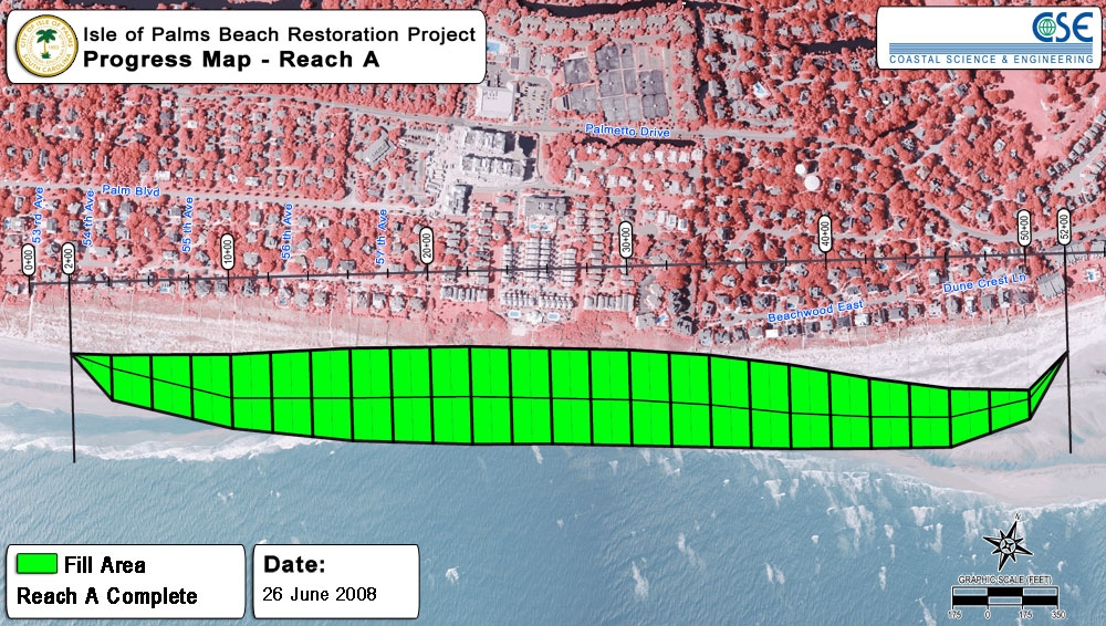
June 26, 2008
The dredging and pumping are complete well ahead of schedule. View a map of the completed fill in Reach A. The Dredge, "R.S. Weeks," has left the waters surrounding the Isle of Palms. Work will continue as pipes and equipment are removed from the beach, final surveys are completed and the sand is tilled.
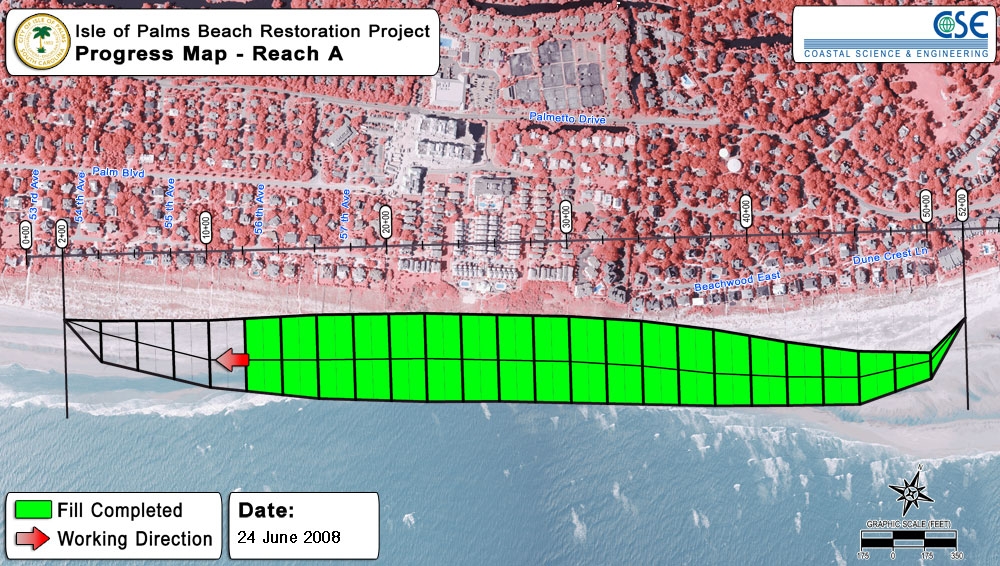
June 24, 2008
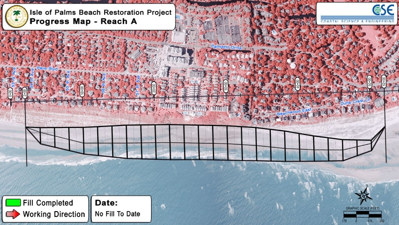
View a progress map for Reach A.
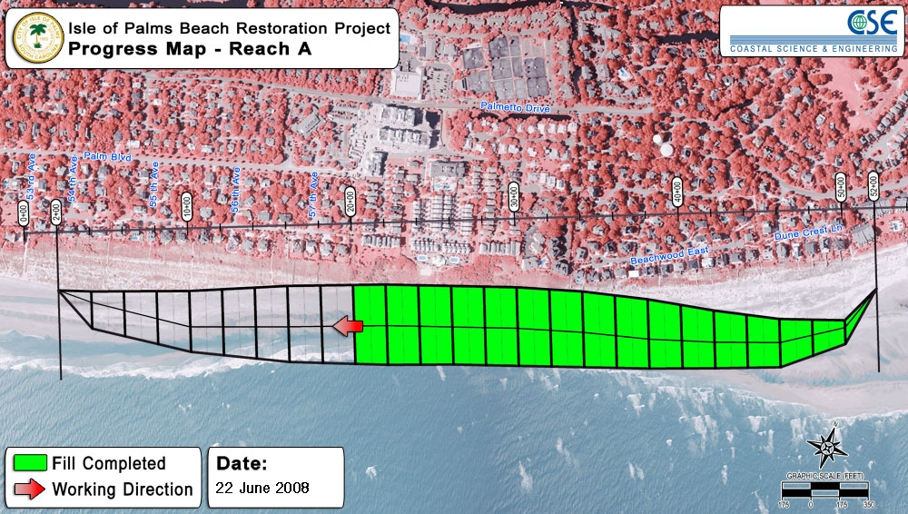
June 22, 2008
View a progress map for Reach A.
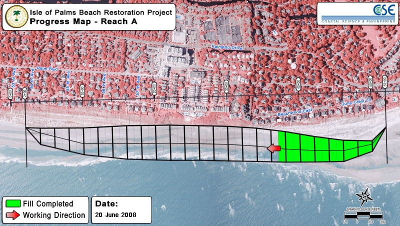
June 20, 2008
View a progress map for Reach A.
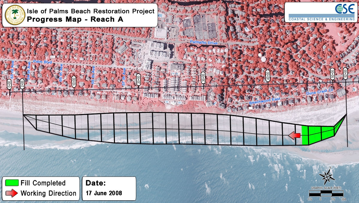
June 17, 2008
View a progress map for Reach A.
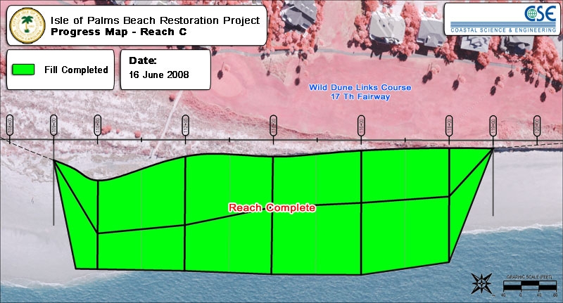
June 16, 2008
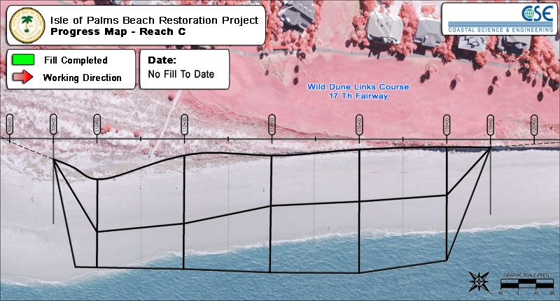
The fill has been completed in Reach C.
June 15, 2008
View a progress map for Reach C.
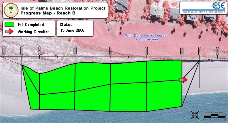
June 14, 2008
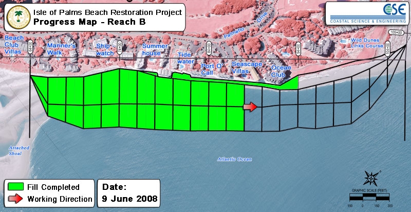
The fill has been completed in Reach B.
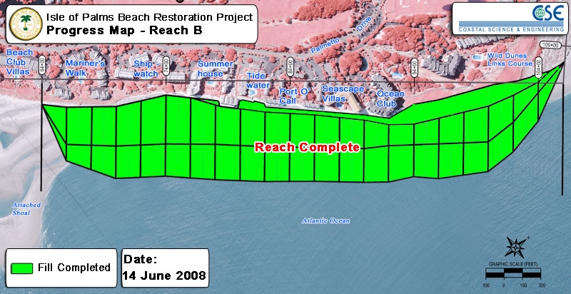
June 13, 2008
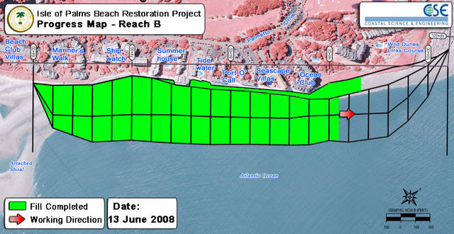
View a progress map for Reach B. To date, no fill has been placed in Reach A or Reach C.
June 12, 2008
During construction, a historic, 128-pound cannon ball was excavated onto the beach. The cannon ball was evaluated by Charleston County and state explosive teams as well as by a historian with the National Park Service. The cannon ball was safely removed from the project area.
June 9, 2008
View progress maps for Reach A, Reach B and Reach C.
June 2, 2008
Approximately 8,600 sand bags have been removed to date. Dredging and pumping continue as scheduled.
May 27, 2008
Over the Memorial Day weekend, the dredge took up position and began pumping sand onto the beach. Visitors can see the "slurry," a mixture of water and sand, coming out of the pipe. Soon, the slurry will dry into a sandy beach. The operation will officially run 24 hours per day, 7 days per week until the project is complete. Sand bag removal continues as scheduled. The City appreciates your patience during construction.
May 22, 2008
The Dredge, the "R.S. Weeks," has arrived in Charleston and should be visible in near the project borrow sites shortly. The dredging and pumping of sand is anticipated to begin over the Memorial Day weekend. Sandbag removal continues at a good pace. Visitors to the beach will notice that the beach is active with construction equipment as pipe is laid in preparation for the pumping of sand.
May 19, 2008
Sandbag removal began this morning and will continue as the project progresses. Please stay clear of the construction equipment.
May 15, 2008
The City received final approval from the United States Army Corps of Engineers regarding a monitoring plan for the project. Weeks Marine has mobilized equipment and is placing pipeline on the beach and submerging pipeline in the ocean. The dredger is en route to the project site. Monitoring for sea turtles has begun. The City requests your cooperation for the temporary (until July 31, 2008) noise, lights and construction equipment. Please avoid the construction area, pipeline and heavy equipment.
May 7, 2008
The United States Army Corps of Engineers issued Permit Number 2007-02631-21G (pdf, 3 MB) for the beach restoration project, and the City signed the permit.
May 5, 2008
The City hosted two meetings related to project construction. The first included representatives from the South Carolina Department of Natural Resources, the United States Fish and Wildlife Service and the Island Turtle Team to discuss the protocols and protections for endangered species during the project. The second focused on logistical issues of project construction.
May 2, 2008
At a Special Meeting, City Council passed a motion to accept the lowest bid placed by Weeks Marine and to amend the volume of sand to be dredged from 780,000 cubic yards to 845,000 cubic yards for a contract totaling $8,386,850, contingent upon the City's receipt and approval of the permit from the United States Corps of Engineers.
April 24, 2008
The City hosted a public bid opening for the Beach Restoration Project and recieved bids from Great Lakes Dredge & Dock Company, Weeks Marine, and Norfolk Dredging Company. At this stage, the bids undergo a formal review.
April 16, 2008
The City and Coastal Science and Engineering hosted a mandatory pre-bid meeting where contractors interested in bidding on the project received essential information, asked questions and made a project site visit.
April 15, 2008
The City received signed agreements from parties involved in the project. In addition, funds received from involved parties were deposited in the IOP Beach Restoration Escrow to be used for the project.
March 18, 2008
The South Carolina Department of Health and Environmental Control Ocean and Coastal Resource Management issued the City of Isle of Palms Permit 2007-02631-21G-P (pdf, 2 MB) for beach renourishment.
February 19, 2008
Mayor Mike Sottile and City Administrator Linda Tucker attended the Charleston County Council meeting in support of the City's application for financial assistance. Charleston County Council approved the request and contributed $900,000 towards the project.
January 17, 2008
The City of Isle of Palms made a formal request to Charleston County for fiscal assistance with the erosion crisis and beach restoration project.
January 11, 2008
At the request of the permitting agencies, the City of Isle of Palms filed an amended permit application with SCDHEC OCRM and USACE that modified the proposed construction schedule. The modified permit application stipulates that all construction must be complete by July 31, 2008. The impetus for the amended construction schedule was to ensure removal of sandbags from the beach before any potential fall/winter storm activity to provide maximum protection to the citizens, the environment and the structures.
January 11, 2008
The City of Isle of Palms entered into an agreement with Coastal Science & Engineering to plan, permit, engineer and administer services related to the project.
January 10, 2008
City Council passed a motion to contribute $1,700,000 to the project in addition to funds previously committed. Per the motion, the $1,700,000 will be generated with a revenue bond.
Project Summary
The northeastern end of the Isle of Palms endured a severe erosion crisis as a shoal attached to that section of the island. If the acute episode continued unabated, structures could have been threatened. In order to protect the public safety and to ensure that the beaches remained healthy, the City undertook a beach restoration project in the spring and summer of 2008. The South Carolina Department of Health and Environmental Control office of Ocean and Coastal Resource Management (SCDHEC OCRM) issued the City a permit that stipulated "up to 885,000 cubic yards of sand will be dredged from four offshore borrow sites and pumped via hydraulic pipeline to renourish 13,785 linear feet of beach." This project restored the dry sand beach, controlled the erosion and included the removal of all sandbags placed in the erosion area
The City of Isle of Palms Local Comprehensive Beach Management Plan, including Appendices, was approved by SCDHEC OCRM on April 7, 2008.
Beach Monitoring
As part of the permit requirements for the 2008 project, the City executed a pre-project monitoring in May 2008 and post-project monitorings in October 2008, May 2009, September 2009 (Year 1), May 2010, September 2010 (Year 2) and June 2011 (Year 3). Included in the post-project monitoring are surveys of the beach and borrow areas as well as benthic analysis. Another important part of the post-project monitoring was compaction testing, which determined whether the sand needs to be tilled before the start of turtle nesting season.
Monitoring of the entire seven miles of Isle of Palms beach has been planned for 2012, 2013 and 2014.
2008 Project Frequently Asked Questions
When did the project start?
The project began over Memorial Day weekend 2008.
When did the project end?
Project construction was completed in early July 2008.
Where did the project start and end?
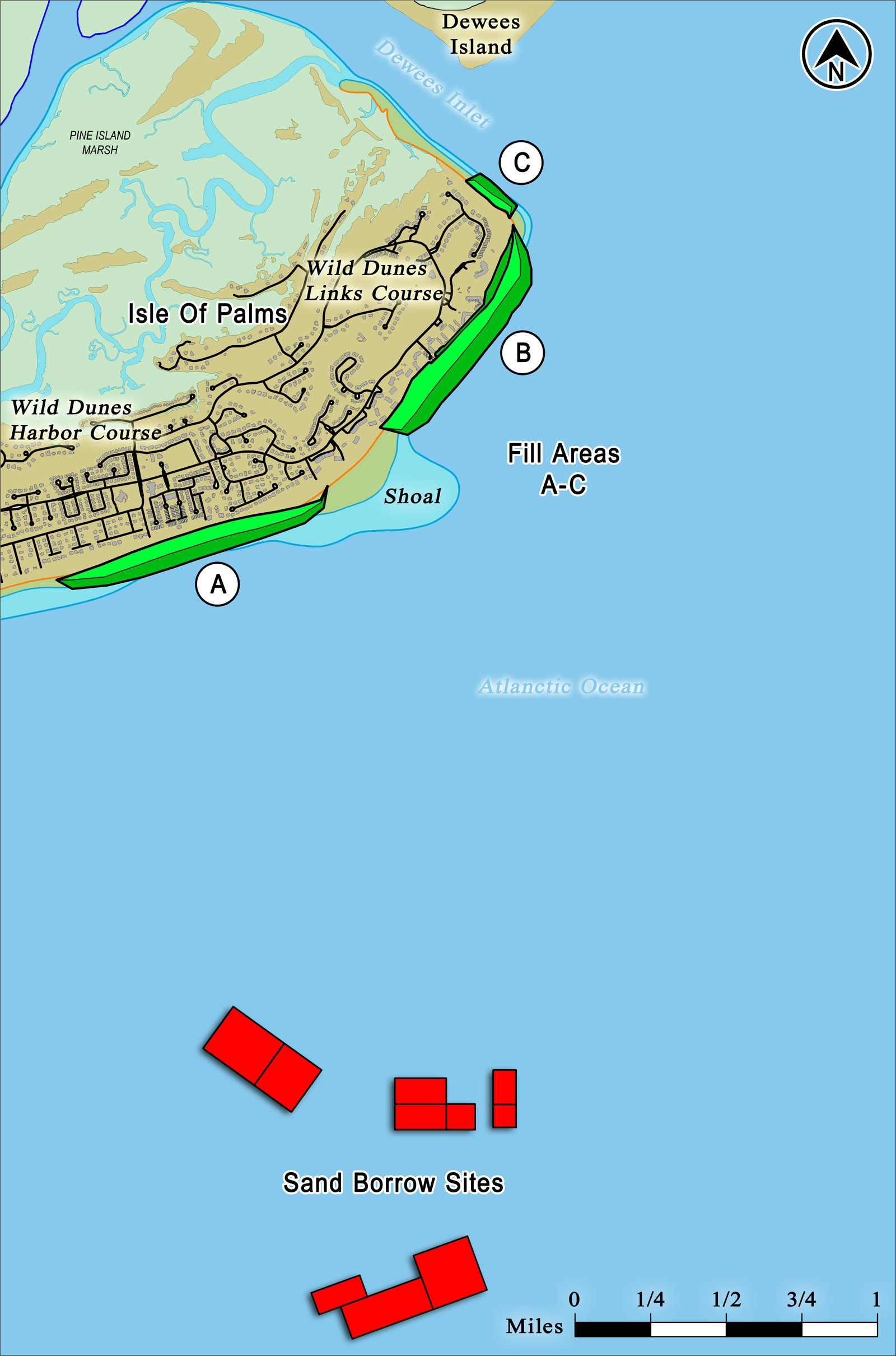
The restored beach runs from 53rd Avenue to Dewees Inlet. The project map shows that sand was placed in three major areas called Reach A, Reach B and Reach C. Where the project starts and ends exactly, including where construction occurred on any specific day, depended on several variables including weather conditions and material conditions.
What about the sea turtles that nest on the Isle of Palms?
The City continues to work closely with all appropriate local, state and federal agencies to ensure maximum protection for sea turtles. The permits issued by the agencies allowing construction to occur include clear guidelines to protect sea turtles. Every night and every morning, turtle monitors walked the construction area looking for turtles and their tracks, and if one was found, the appropriate steps were taken to protect the turtle and its nest.
Did the project run all day and night?
Yes. The project did run 24 hours per day and 7 days per week. The goal was to complete the project as soon as possible, so unless inclement weather forced a delay, construction continued all the time. The project was completed several weeks ahead of schedule thereby minimizing disruption to beach goers.
What was construction like?
The City contracted with Weeks Marine to perform the construction. Beach restoration is a large project that involves an off-shore dredger, large pipeline and heavy equipment and trucks. Visitors and residents in close proximity to the project encountered this large equipment and heard the accompanying noise. At night, lights illuminated the beach so construction could continue. These disruptions were temporary as the project moved down the beach.
Was the beach closed?
The restored beach is approximately 9,200 feet long, but only a smaller section of the beach was under active construction on any given day. The section under construction was clearly marked and closed to visitors. The rest of the beach was open as usual. Also, the construction was progressive, meaning it moved along the beach during construction.
Did the project affect boaters?
Boaters needed to be aware that pipeline, marked with buoys, was be submerged in the waters around the project.
What about the sandbags?
As part of construction, all the sandbags were removed from the beach.
What was the beach like when the project was completed?
November 20, 2007
The City of Isle of Palms applied with SCDHEC OCRM and the United States Army Corps of Engineers (USACE) to receive a permit for beach renourishment.
November 13, 2007
At a Special Meeting, City Council received a presentation of the Long-Term Beach Management Plan and passed a motion to initiate the permit application process for a beach renourishment project using $200,000 allocated in the FY08 budget for beach erosion.